Blog 9 – Karijini and beyond – adventures in the Pilbara – October 2008
We learned of Karijini National Park while we were still in Canberra. A Tai Chi student of Peter’s showed us photos of his many travels around Australia, and we remember being struck by the ones of ‘that place with the magnificent gorges’.
Next, we heard about the park while staying in Ceduna, just before we crossed the Nullarbor. A very friendly, enthusiastic lady from Mandurah, south of Perth, was going around the caravan park telling all of us easterners that we must visit Karijini. This became a standing joke between us – “Young lady/man, you really must visit Karijini”.
So we did.
EXPLORING KARIJINI NATIONAL PARK
We left the mining town of Tom Price and headed into the western side of the Karijini National Park, in the heart of the Hamersley Range, in the central Pilbara. The region is ancient, to say the least. Some of the rocks in the park originated more than 2,500 million years ago as iron and silica rich sediment deposits on an ancient sea floor.
The road into Karijini seemed almost as old and was heavily corrugated. Our first impressions were underwhelming, to say the least, as we rattled our way along the dusty road. We headed towards the Karijini Eco Retreat – a fancy name for our bush campsite, although the retreat did offer hot (solar) showers as well as drop dunnies, a relative luxury by our usual standards. The broader retreat also offered luxury tents, a restaurant and a bar, all in a largely unspoilt natural setting.
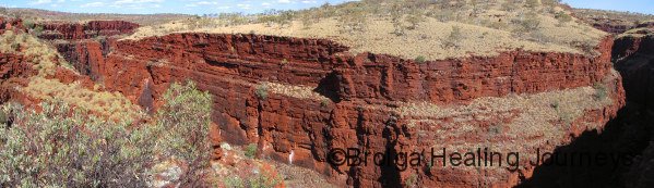
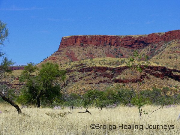
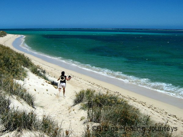
After setting up camp we decided to visit some nearby gorges. As we drove towards them the countryside consisted largely of undulating hills, making it difficult to imagine any gorges in the area. Still, on we headed, parked the car and walked towards Oxer Lookout. I (Peter) walked on ahead, looked out, then turned to face Nirbeeja with my jaw hanging somewhere near the ground. And it was indeed a jaw-dropping view. The Weano, Hancock and Red Gorges, each at least 100 metres deep, converged before us. The cliffs were a mixture of deep red and chocolate brown, making a striking contrast to the pale spinifex-dotted country surrounding them. Far below we could see water rushing through narrowed cliffs, and we spied tiny coloured ants walking along the water’s edge – hang on, they weren’t ants, they were people. What a sight!! The contrast between the sheer magnitude of the gorges and the relatively unremarkable surrounding countryside was stunning. We stood, gaping at the view for some time, eventually dragging ourselves away to descend the steep trail (and metal ladders) down into Hancock Gorge. The hot, dry conditions above the gorges were transformed into air-conditioner like comfort as we descended. We walked along the base of the gorge for some distance, encountering a series of waterholes, until we reached as far as we could short of plunging into the river. I later explored some of Weano Gorge, while Nirbeeja sensibly rested in the shade, before we called it quits for the day.
We returned to our campsite, savouring our first taste of Karijini. We were camped in an open area (poetically named the Savannah campsite) within the Eco Retreat, with a nearby Snappy Gum providing some early morning shade. We opted to camp near rather than under the Snappy Gum, given its name.


Over the next couple of days we travelled out from Savannah to explore a number of other gorges in the region. Each was breathtakingly beautiful and special in its own way. Knox Gorge featured a gorgeous waterhole; the perfect spot for lunch. Nirbeeja quickly settled down next to the pool and I wondered how I might ever convince her to leave. Downstream, the high cliffs of the gorge sheltered the crystal clear waters of the river below. We wandered along the gorge as far as we could – until the point where abseiling was required to continue, and since we didn’t have any such gear (or experience) we opted for the safer option of retracing our steps.
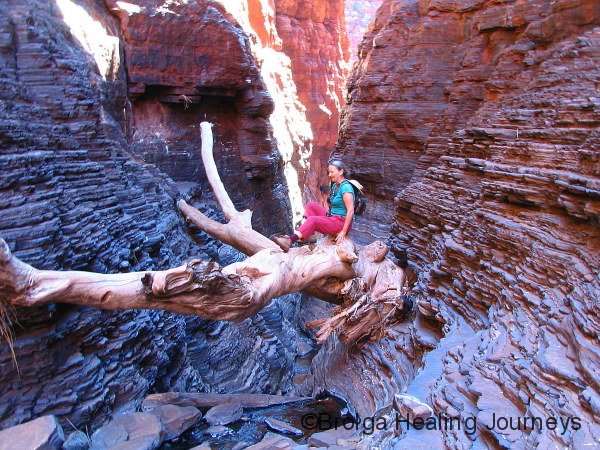
As an aside, the various walks in WA National Parks are graded from Class 1 to Class 6, with Class 1 walks being a stroll in the park and Class 6 walks requiring national abseiling and rock climbing accreditation before they’ll let you anywhere near them. There are many walks in Karijini from classes 2 to 4, several of class 5 status, and a number of class 6 walks/climbs/plummets into oblivion. We opted for a lot of class 3 and 4 walks (and a couple of class 5s), tough enough going without requiring Special Forces training!
Anyway, the track from the car park to the bottom of Knox Gorge was steep, rough and tricky in parts with lots of loose rock. It was worth every bit of its class 4 rating. We took our time climbing down because it would be a quick, painful way to the bottom if you lost your footing. We had finished our explorations of the gorge and were psyching ourselves up for the ascent, just as three young, fit looking German tourists finished their descent. It seems they also thought class 4 slightly understated its difficulty. We both cracked up when one friendly young guy, in a thick German accent, said “That’s class 4 track? F*#k”!
We visited Joffre Falls, nearer to ‘home’, featuring a huge natural amphitheatre and waterfall. Some water was passing over the falls while we were there, though by all accounts it is an even more impressive sight after rain. The amphitheatre sheltered an enormous pool at the base of the falls, and a stream led from the pool into a gorge below, which narrowed spectacularly before plunging over a steep, narrow cascade to another further waterhole, tantalisingly beyond our reach. Many of the gorges in Karijini were like this – offering us glimpses of beautiful but inaccessible areas further along.
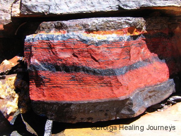
Kalamina Falls and Gorge were equally beautiful. The falls would not look out of place in the garden of a Zen master. The water cascades down countless small terraces to the pool below, which is surrounded by ferns and overlooked by Paperbark trees. The water is crystal clear, and cold too, as I discovered when I opted for a dip. Nirbeeja wasn’t so brave, instead opting to capture my discomfort on camera! (But fear not, there’ll be no photos of me in my underwear this time.). The gorge downstream of the waterfall featured some amazingly coloured rocks, and twisting patterns in the sedimentary rocks. We wondered at the immense pressures required to distort the rocks in such a way.
As if to offset all this beauty, the road from Savannah to Kalamina falls was an absolute shocker. We saw several 4WDs along the road replacing shredded tyres, and we were relieved to complete the return trip intact. We later learnt that the road hadn’t been graded for many months, because the grader had been dragged away instead to work on the roads to the mines. Ah, how money talks; the poor old National Parks just can’t compete with those guys!
For our final night at Savannah we ‘lived it up’ in the Eco Retreat’s restaurant – a belated celebration for Nirbeeja’s birthday. It was a lovely way to end our stay there.
From there we moved further east in the park, staying a couple of nights at the Dales Campground. On our arrival we were warned to lock all food, rubbish and even clothing inside because of the local dingo pack. In the past we’d been assailed by marauding packs of possums, but never dingoes. We followed instructions, fortunate really because each night we heard the pad of many paws outside the camper, and were entertained by the periodic howls of the local dingoes (well, either that or a bunch of feral backpackers).
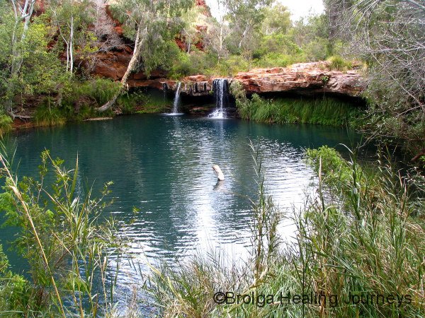
We explored the Dales Gorge area of the park, marvelling at the Fortsecue Falls, Fern Pool and Circular Pool. These too were beautiful and by now our book of superlatives had been torn up and thrown away. Anyway, Fern Pool was exquisite- a pool surrounded by native fig trees and maidenhair ferns – the perfect spot really. The walk in to the pool is like something from the Old Forest in Lord of the Rings. Huge fig trees adorned by Flying Foxes, followed by scenes of intertwining rocks, tree roots and ferns in shady recesses. The place has a sense of peace, and of great antiquity. The water of the pool, as we had found throughout Karijini, was crystal clear and home to numerous fish.
Fern Pool is a sacred place for its traditional custodians, who consider that the Rainbow Serpent still inhabits its waters. Whilst they are happy for others to visit the pool and to swim in it, they simply request that people behave respectfully and quietly while they are there. It is a contemplative place, by any measure, so one would expect people to behave that way without conscious effort. Of course, that proves too much for some visitors, who insist on yahooing, drinking beer and generally making a nuisance of themselves. Fortunately, they are the minority, but they sully the experience for others and reminded us that, at times, our society lacks the capacity for reverence. (Sorry folks, we realize we’re indulging in some spleen-venting here. We aren’t wowsers – we love a swim and a drop of wine, but there’s a time and place for everything.)
Circular Pool was larger and more imposing than Fern Pool, but likewise had a peaceful and timeless quality. The pool, formed at the base of high surrounding cliffs, is deep but the water so clear that the rocks at its bottom are easily seen.
We had one final part of Karijini to explore; Hamersley Gorge. This was on the northern fringes of the Hamersley Range, and a considerable distance from either the Eco Retreat or Dales campground. With this in mind, we packed up and decided to visit the gorge en route to Millstream Chichester National Park, further north in the Pilbara.
WHATEVER HAPPENED TO WITTENOOM?
The road to Hamersley Gorge took us past the ghost town of Wittenoom. The township once supported an asbestos mine in nearby Wittenoom Gorge, but the mine was closed many years ago both for economic reasons and health concerns, and the township dwindled as a result. It seems the WA government is intent upon erasing all trace of Wittenoom. Its name has been blanked out from all road-signs, the road once bearing its name has been renamed, power supplies cut off and the township abandoned. Roads in the ‘town’ and crumbling into rubble and, by all accounts, only a few brave, stubborn souls still live there.
We had been told about the beauty of Wittenoom Gorge, so we decided to explore the area on our way through, albeit after taking precautions to close our car windows and have the air-conditioner on recycle to minimise the risk of inhaling blue asbestos tailings. (Blue asbestos is prevalent through much of the rock in Karijini National Park – Nirbeeja found a vein of it through the rock at Dales Gorge – but is only dangerous when released into the air through human activity such as mining.) The gorge lived up to expectations, with some stunning cliffs, rock formations and pools. It was sad to think such a beautiful area is now largely off-limits due to an environmental hazard of our own making.
The stark beauty of the Hamersley Range was a constant companion as we continued towards Hamersley Gorge. The gorge proved a fitting finale to our time in the national park. The cliffs featured the most dramatic rock patterns we had seen, and the small but beautiful Spa Pool proved a high point on which to leave.
We drove out of Karijini National Park with a sense of loss. Its gorges had surpassed all expectations. Each was unique, their patterned rocks varied and beautiful, their waters crystalline, and their vegetation unexpectedly luxuriant in an otherwise arid region.
MILLSTREAM-CHICHESTER NATIONAL PARK
We reached Millstream Chichester park late in the day, exhausted from a long day’s drive along at times very rough roads and our explorations on foot through Hamersley Gorge. We had hoped to camp beside the Fortescue river at Crossing Pool, but there was ‘no room at the inn’ so to speak, with the small campground full, so we settled for a bush-campsite at Stargazer’s campground elsewhere in the park. There was no water there but we enjoyed the bush setting nonetheless.
The national park is really in two sections; the oasis surrounding the natural springs of Millstream (along with an historic homestead nearby, which now doubles as visitor centre) and the dramatic formations of the Chichester Range further north.
The area surrounding the springs was beautiful. We had thought the waters of Karijini clear – but the water near the springs was mesmerisingly so. We could have sat and stared into those waters for ever!! The pool, named Chinderwariner by the local aboriginal peoples, was an important campsite for inter tribal meetings. Because of its cultural significance, swimming is not allowed in the pool, which probably goes some way to explaining its continuing pristine state. Swimming is allowed at the Crossing and Deep Reach Pools along the nearby river, and we can attest to the revitalizing qualities of swimming in those pools after bush-walking on a hot day.
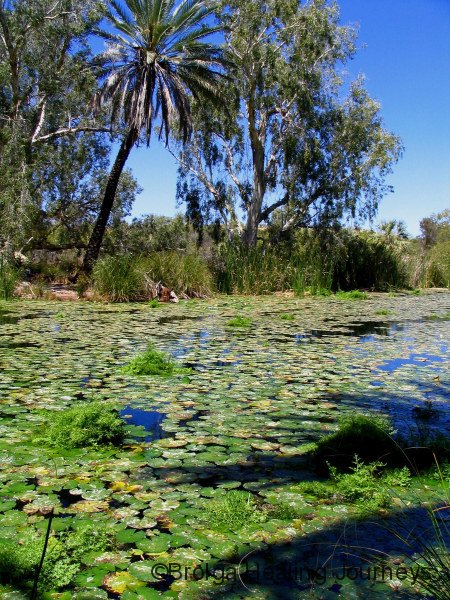
The Millstream area is a haven for bird and plant-life, as the springs provide a permanent water supply; rare within the Pilbara. As with many oases, some plants are unique to the region, including the Millstream Palm (Livistona alfredii). Similar species of these ancient palms are found in isolated areas within the Kimberley and the MacDonnell Ranges.
We met the Aboriginal ranger Ken while we stayed in the park. He was very generous in sharing with us some of his people’s stories about the region, which greatly enriched our experience in the park. It was fascinating for us to hear his understanding of the cyclone that afflicted the park several years ago, and it made us wonder just whose viewpoint of the cyclone was the more valid – our scientific one or the Aboriginal one based on thousands of years living with the energies and spirits of a region.
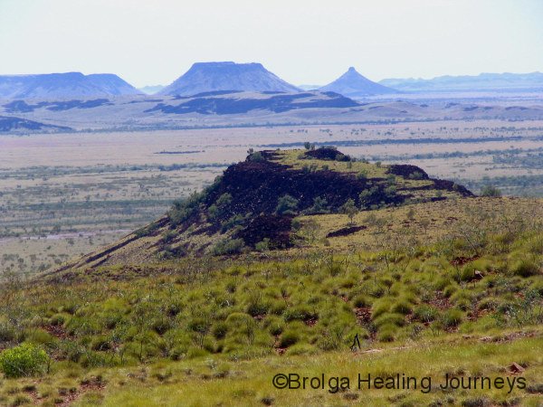
We explored the Chichester Range en route to Karratha. The range features some dramatic eroded mesas and rock formations and gave us our first glimpse of the huge hillsides of boulders that would feature in the Karratha and Burrup Peninsula regions. We also visited the beautiful Python Pool, nestled at the foot of the range. We didn’t see any pythons, but with the names of this pool and the nearby Snake Creek in mind, I must admit that I trod carefully in this area!
KARRATHA, DAMPIER & BURRUP PENINSULA
LOTS OF ROCK ART – AND CONTRASTS OLD & NEW
We never thought we’d admit to it, but the drive from Chichester Range to Karratha along a bitumen road was an absolute joy. Ah, the sheer pleasure of a smooth road beneath our tyres!! The road travels parallel to the railway tracks from Tom Price to the port facilities at Dampier. Nirbeeja amused herself attempting to count the number of carriages in the serpent-like trains making their way to and fro, only to be thwarted again and again by hillsides and bends. But her count did get as high as 245 carriages, plus the three engines, in one train, before she lost sight of the rest of it behind a hill. These trains simply have to be seen to be believed.
Karratha was our first taste of civilization for some time. The town is relatively new and was built in the early 1970s to support the mining industry. Shopping facilities are modern and air-conditioned, and we were surprised to learn that Karratha has the second busiest airport in WA. (Apparently, many mining workers fly in from Perth for each week-long shift and then fly home when it ends; testimony to the money they earn and the shortage of accommodation in Karratha.) After travelling on remote roads in the Pilbara, where you wave at every car you encounter, the frantic pace and volume of traffic in the town frazzled our nerves.
We stayed one night in Karratha, before heading out to a small caravan park in the nearby town of Dampier, on the Burrup Peninsula. Despite hosting an incredibly busy port, (indeed, the port of Dampier accounts for 15% of Australia’s export earnings) Dampier is a sleepy, attractive bayside village. Dampier is a place of contrasts, to say the least; look straight ahead and you see the pristine ocean and the largely untouched islands of the Dampier Archipelago, but turn your head and you face a line of supertankers at the dock! There is a constant procession of cargo ships to and from the port, carrying iron ore to China, natural gas to Japan, and fertilizer and salt to all parts of the globe.
Dampier was our base for exploring the Burrup Peninsula. As you can probably tell by now, we are fascinated by Aboriginal rock art. Well, we had seen reports about the extent of Aboriginal rock art in the region and were keen to explore. Depending upon what you read, there could be anything from 10,000 to 1 million individual petroglyphs (rock engravings) in the region. The oldest petroglyphs have been dated to at least 20,000 years, and these are the most difficult to see as they are the faintest; many are barely distinguishable from the background rock. The newer works are far more apparent, so it pays to take your time and have a good look around in order to discover all that is there. Once you grow accustomed to looking for the petroglyphs, it is amazing how many you find. Most art works portray animals and sea-life found in the region, but some are more ritualistic in nature. Most of the works feature an outline of the subject chipped about 1cm into the rock. This would have taken quite some doing, because the rocks are extremely hard and the artists only had primitive, rock-based tools. The most impressive works feature entire panels chipped away smoothly from the rock – for instance, the area representing the whole body of a kangaroo may have chipped away.
We spent a couple of days seeking out the art. All I can say is that we were in rock art heaven – and although we can’t provide any clarification to the official total, we did see many hundreds of petroglyphs…..and we just scratched the surface, only really exploring two small areas. I just about wore out the camera photographing them and we probably risked life and limb climbing around the precarious ‘hillsides’ consisting of high mounds of dark red boulders. Everywhere you turned there was a petroglyph. Nirbeeja would go off on her own explorations and call out her dramatic finds to me, and I’d clamber across with camera in hand. We probably looked a bit crazy to any onlookers, climbing around these boulders for hours on end, in the blazing sun, but we loved it. Other people would walk up the valley between the boulders, look around for five minutes (at the most) and then wander off disappointed at not having seen much art. So we feel that our adventurousness was repaid. We’ve reproduced a few of the photos below, but I took photographs of over 400 separate art works. If anyone is interested in seeing more, please contact me and I will send you a CD of the photos; I feel this is an important cultural and historic site and the more people who find out about it, the better.
Here is a selection of photographs of the rock art. For more photos please refer to our post entitled “Aboriginal Rock Art of the Burrup Peninsula”, in the Rock Art category of this site.


The mining and gas industries have a huge say in what happens in the region. They have big money on their side, after all. Tourism has enormous potential in the area, with the Dampier Archipelago offering the pristine beauty of its islands, and the Burrup Peninsula housing the world’s most extensive collection of rock art. But we feel these attractions are unlikely to realize their tourism potential because of the power of industry and the complicity of governments. There seems almost a concerted effort to downplay the region’s attractions, so as not to interfere with the development of heavy industry.
We know it is important to develop our industry, but it seemed to us very much a case of develop at all costs in this region. To show we aren’t totally anti-development, we were both blown away by the incredible technology and sheer level of achievement on show at the natural gas facilities on Burrup Peninsula, and at the economic contribution made by the region’s industries. It just seems a tragedy that the port and refining facilities were built in a region of such enormous cultural and natural value, when up and down the coastline of WA are many areas of far lesser significance that could equally have housed such facilities.
We also went on a sailing adventure around the Dampier Archipelago onboard the yacht Spinifex Spray, with laid-back skipper Brad and a few other intrepid adventurers. This was a lovely way to explore the region, although by late afternoon the winds and swell had come up and our trip back to the wharf was hardly plain sailing (if you’ll excuse the pun). The boat rocked wildly to and fro as we crossed open stretches of water, to the extent that Nirbeeja and I were seriously contemplating our actions in the event of capsizing. I am usually the world’s worst seafarer but can happily attest to the benefits of natural medicines; I felt perfectly well all day (a big cheer for homoeopathic Cocculus and some ginger root to chew on).
We saw a couple of dolphins from the boat, but were disappointed to learn that their numbers, as well as those of turtles, had steadily diminished in the area due to blasting for construction works around the docks. It was, nonetheless, a great day and we slept well that night after a day spent breathing deeply of the fresh sea air.
We ventured a little further up the coast, staying a few nights at Point Samson, allowing us to explore the nearby region, notably Roebourne and the ghost-town of Cossack. We particularly enjoyed Cossack, now a heritage preserved township. Cossack was once a thriving port and pearling-centre long before Broome, but declined over a century ago following a series of devastating cyclones and the need to look elsewhere for a deeper harbour. Often we have felt a bit museumed-out during our travels, especially when confronted by an overwhelming amount of stuff in museums; but Cossack got it spot on regarding the amount it offered, so that we found all the information could be absorbed and enjoyed.
WE HEAD SOUTH, VIA PANNAWONICA (OR WAS THAT PANNA MONICA)
Much as the Kimberley beckoned, we turned tail and headed down the coast at this point. We were already encountering days in the high 30s, and the prospect of temperatures in the mid to high 40s further north, didn’t attract us. The Kimberley can wait for next year. We also had our sights set on getting work over the summer in Carnarvon.
So down the highway we went, venturing inland to the mining township of Pannawonica. I had first heard of Pannawonica nearly thirty years ago when I was a fresh-faced young lad, but at that time was unable to locate it on any map. So my curiosity was aroused, and Alick (from Geraldton) had also given us directions to a bush campsite in the region. Well, Pannawonica proved to be a nice, neat, friendly little town with a well stocked and cheap supermarket, but the campsite proved more elusive. We tried to follow Alick’s directions to the site but it seems the mining companies are putting in new roads as fast as their bulldozers can travel, so it was pretty confusing. A road-worker tried to help out with directions, but when he kept referring to the township as Panna Monica, some doubts arose as to the depth of his local knowledge!
Eventually, we did find a road to the camp only to discover that it was blocked to all but mining traffic, so we conceded defeat and retraced our steps to the main highway heading south.
We settled for an overnight stay at a free camp within the Cane River Conservation Park. It was a hot spot in the late afternoon sun, but it was nonetheless pretty and we enjoyed camping beside the river which, unlike many in the region, contained water in some of its holes. We were fortunate to have the place all to ourselves.
We awoke the next morning to one of the most amazing sights of our travels. Flock after flock of budgerigars flew overhead along the river course. Each flock contained many hundreds of birds, and flocks passed continuously overhead for three quarters of an hour. It would be no exaggeration to say that we must have seen hundreds of thousands of budgies. Some flocks were almost deafening with their squawking, while with others the only sound was that of their massed flapping wings, and they nonetheless sounded like a passing truck. Some flocks settled in trees around our campsite, with branches straining under the weight of the birds. Nirbeeja, not surprisingly, was jumping out of her skin with the thrill and excitement of it all and nearly sent herself hoarse with her excited yells! I was excited too, though for me the thrill was tempered slightly by the lack of camera to record the event, as it had broken down the night before. But what a sight! The memory of flashing greens and yellows en masse, swooping down then suddenly changing direction, as if controlled by one mind, will stay with us always. We had read about massed flocks of budgies but never dreamed that we should be so lucky as to witness them ourselves.
EXMOUTH, CAPE RANGE & NINGALOO REEF
I managed, eventually, to drag Nirbeeja to the car and to leave that spot, bribing her with the promise that we would one day return to witness the budgies again. We travelled a good part of the day across to Exmouth on the North West Cape. Exmouth is a smallish town, now mostly reliant upon tourism, but having been established many years ago to support a naval communications base (and US spy-communications base). It now serves as a base for trips to the Ningaloo Reef, famous for its coral reef and whale sharks.
As with Karijini, seemingly everyone we had met on our travels had raved about the Cape Range National Park and the adjoining Ningaloo Reef Marine Park. They had also raved about how difficult it was to get a campsite in the park. We had heard horror stories about a daily line-up of cars at the park gates at 7.30am as people hoped to secure a campsite.
We had been lucky getting sites so far on our travels, but would our luck hold out just once more? So we visited the National Parks office in Exmouth, fingers crossed, and – yippee – we got the last spot available in the park. (We stayed in the park for just short of two weeks and can attest that camping spots were snapped up as soon as they became available. The “Camp Full” sign was a constant feature at every campground in the park.)
We loved our time there. We were camped at Osprey Bay, nestled behind sand-dunes, a short walk to what was virtually a private beach for Nirbeeja and I, and a walk only slightly further to the bay and its coral gardens. The Osprey Bay camping area contained 15 sites but was wonderfully spread out – there were at least 20 metres separating each site, so you almost felt that you had it to yourself. It was also a really friendly place, and we had some lovely social gatherings with other campers there. The only downside was the wind – the bloody wind – that at times threatened to blow us away. Exmouth holds the Australian record for wind speed with 267km per hour. Okay, so the winds weren’t quite that strong during our stay, but at times we felt that the camper (and us) would be lifted up and carried away. It was hard sleeping at night with the canvas sides of the camper being buffeted and the whole camper rocking with the wind. In the end it was the wind that forced us to leave the park. Several days of 30 knots-plus winds, and the forecast of stronger ones to come, was enough for us!
But most of our stay there was a joy. The coral at Ningaloo Reef can be accessed easily from the shore (unlike the Great Barrier Reef), and we had some wonderful times snorkelling at (our own) Osprey Bay, and at Turquoise Bay and Oyster Stacks. We marvelled at the shapes, sizes and colours of the coral and the amazing variety of colourful fish swimming everywhere. The water colour there is a stunning, almost iridescent turquoise. We were also excited to see giant turtles everywhere – one afternoon I counted nine during one walk along the beach – and I was thrilled to swim near one at Osprey Bay. I found it amazing that a creature with such slow graceful strokes from its flippers could be so difficult to keep pace with. I seemed to develop a peculiar affinity with the turtles while we were there and can report, somewhat embarrassingly, that I chanced upon turtles mating in the shallows on several occasions. Nirbeeja would eagerly await my return from my beach walks to hear my latest turtle reports!
Turquoise Bay features two famous snorkelling areas. One of them is the Drift Loop, where you enter the bay at one end and allow the strong current to carry you across the coral reef to the other end; you simply float along and enjoy the view. You just have to know when it’s time to get out, or it’s next stop Madagascar! As our friend Claire reported to us many months ago, it’s snorkelling for couch potatoes.
But there’s more than just snorkelling to do. We spent many hours in a bird observatory watching Sea Eagles, being entertained by a friendly little Mangrove Fantail, and trying to identify the many wading birds at Mangrove Bay.
We explored the dramatic and colourful Mandu Mandu and Yardie Creek gorges along the walk trails, returning to the latter for a boat cruise that allowed us to see the endangered Western Black-Footed Rock Wallaby, a nest of Nankeen Kestrel chicks, along with other wildlife.
Our only disappointment was not seeing the Whale Shark – we were there during the wrong season for that. But we have avowed to return next year when they are around.
BACK TO CARNARVON
So off we headed, along with most of the inhabitants of our camping ground, seeking shelter inland from the wind. We stopped off in Exmouth for supplies (the day before the emergency landing by the Qantas jet) then headed towards Carnarvon via a quick stop to have a look at Coral Bay.
Coral Bay is at the southern end of the Ningaloo Reef. It is very popular with families, has a beautiful bay and beach, and also has coral easily accessible from the shore. But we arrived during school holidays and suffered severe culture shock at the number of people there. It was swarming. Maybe it would be nicer after the holidays, but we freaked out at the sight of massed humanity, and high-tailed it out of there. It had been school holidays too while we stayed in Cape Range, but we know where we’d rather stay.
So now we are back in Carnarvon, after a memorable time exploring the central Pilbara and down the Coral Coast. We hoped to find work on our return to Carnarvon but had been warned that things were quiet here at this time of year, so we hoped for the best. Anyway, we bought a local newspaper and only two jobs were advertised – one job doing bookkeeping and the other working on a banana plantation. We got them both – I’ll be doing the bookkeeping and Nirbeeja the banana-bending (as they say, you can take the girl out of Queensland….)
Hopefully we’ll pick up more work here and stay long enough to get some Yoga and Tai Chi classes going and my clinic up and running.
Till next time…
Peter & Nirbeeja
10 October 2008
